© 2020 (Do not copy or redistribute this document)
Introduction
Bareneed is a small village on the northwest shore of Conception Bay, Newfoundland., Canada.
My Newell ancestors settled in ‘The Dock’, the name for the western part of Bareneed, before 1780 and my grandparents relocated to the center of Bareneed in 1912. There is a separate section of this Web Site that deals with my Newell Ancestors; however this section covers the general history of Bareneed and the Dock.
This report on Bareneed is organized into sections with descriptions of Population trends and Geography presented below and separate sections on Religion, Education and Economy. These are followed by a chronological review of the history of Bareneed provided in separate sections. A Epilogue at the end summarizes the last 50 years of History. Many of these sections are still under construction. The following Index has links to each section:
- Family Names
- Religion
- Education
- Economy
- History 1497-1805 Early Settlement
- History 1805-1818 Descent into Darkness
- History 1818-1837 Recovery and Growth
- History 1837-1901 The Victorian Era
- History 1901-1948 Wars and Depression
- History 1949-1969 A Snapshot of People and Places
- Epilogue
These sections can be accessed by using the links above or by navigating through the Web Site Menu. Going to the menu at the top of any page and hovering the mouse over any item in the Menu (e.g. Bareneed) will show the sub sections under that topic.
Clicking on these will take you to that section. Finally there are links at the end of each section that will take you to the next section.
Population
The first complete snapshot of the residents of Bareneed was a survey of Fishing Rooms compiled c 1805 (see separate History Section for more detail). This was not a true census since it only documented individuals who made claims to ownership of property (Fishing Rooms). This survey captures the state of the fishing community in Bareneed.
The first survey of the total population of Bareneed [Bear Need in report] was compiled in 1817 (see my Census 1817 Section)). This census not only listed householders but also included statistics on their wives, children and servants. The survey was organized by town (Port de Grave, Bareneed, Cupids, Brigus) with Bareneed including people living at the head of Bay de Grave (Otterbury, Northern Gut, Clarke’s Beach, Southern Gut and Salmon Cove). The data for Bareneed was listed in two sections; the first group starting with Thomas Boon Senior who likely lived just east of the current wharf and going east to Jacob Delaney in the east end of Bareneed. The second group starting with John Boone (likely living west of Thomas) and running in a general east to west direction (counter clockwise around the Bay). I have assumed, based on my research, that Isaac Daw (Dawe) was the last resident of what is now Bareneed and that the remaining people in the list were living in what is now the Otterbury, North River, Clarke’s Beach and Salmon Cove. This gives a total of 53 households with a combined population of 325 individuals with an average of 6.15 per household. Using this average we can roughly estimate the population in 1805 to be 184. The first official Census was conducted in 1836 and the data listed for Bareneed in this Census included the Dock and Sandy Cove (west most part of Port de Grave). Attempting to adjust for Sandy Cove I have estimated the population of Bareneed and the Dock to be ~395. From this point there were Newfoundland censuses conducted in: 1857, 1869, 1874, 1884, 1891, 1901, 1911, 1921, 1935 and 1945. In 1949 Newfoundland joined Canada, unfortunately the Canadian data is not available in published reports for small villages like Bareneed.
Using the available population data listed above I have prepared a graph (see below) showing the trend in population between 1805 and 1945.
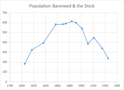
The graph shows that there was a rapid increase in population from 1805 to 1860 then a slow increase from then to 1885 followed by a decline which became steeper after 1900. A quote from the Journal of Governor Thomas Cochrane, written during a visit to Port de Grave in 1824, explains the cause of this increase: the population in all these Bays is on the increase — not from strangers but by Births. The graph does not provide data for the 18th century or for the post Confederation period; however, both of these periods will be discussed in the History Section of this report. Based on my personal knowledge I can state that after 1945 the rate of population decline slowed with the lowest level reached in the 1970s. This decrease resulted from out migration and and decrease in fertility. The fertility rate in Newfoundland has declined steadily from 5.9 (births per adult female) in 1957 (one of the highest rates in the world), to 1.2 in 2000 (one of the lowest rates in the world). After the 1970s there was a slow increase in population in Bareneed resulting from people from Port de Grave moving into Bareneed. Presently (2020) these migrants from Port de Grave likely represent the majority of the population and Bareneed is rapidly loosing its distinct character.
As I indicated earlier, in 1805 there were 30 Planters recorded in Bareneed and these 30 families had 17 different surnames. The survey (census) of 1817 also recorded family names and there was a voters list compiled in 1835. There is no name data available for the censuses conducted between 1837 and 1891; however, there are family name data for the censuses conducted between 1911 and 1945. The following Table tracks the 17 original names found in 1805 over time (in some cases these names were either recorded incorrectly or the spelling of the name changed over time so alternative spellings are shown in brackets). Note: this Table does not track new surnames that were introduced by families moving into the town (mainly from surrounding towns).
| Names in 1805 Plantation Book | 1817 | 1835 | 1911 | 1935 | 1945 |
| Bartlett | Y | Y | Y | Y | Y |
| Batton (Batten) | Y | Y | Y | Y | Y |
| Boone (Boon) | Y | Y | Y | Y | Y |
| Bucham (Beauchamp, Beecham) | Y | Y | Y | Y | Y |
| Cavanaugh (Kavanagh) | |||||
| Curnew (Curlew) | Y | Y | Y | Y | |
| Daw (Dawe) | Y | ||||
| Filleul (Filleut, Philere, Fillieur, Filler) | Y | Y | |||
| French | Y | Y | Y | Y | Y |
| Moore (Moores) | Y | Y | Y | Y | Y |
| Noel (Nuel, Newell) | Y | Y | Y | Y | Y |
| Norman | Y | ||||
| Picco / Preautx (Priaulx) | Y | ||||
| Richards | Y | Y | Y | Y | Y |
| Snow | Y | Y | Y | ||
| Stevens | Y | Y | Y | Y | Y |
| Sullivan |
Based on the surname data presented in this Table it is clear that the majority of the Planters found in 1805 had descendants that continued to live in Bareneed and the Dock well into the 20th century. As part of a separate project I have prepared a Google Map showing the location of houses and their occupants in Bareneed during the 1950s. The families living in Bareneed in the 1950s and the location of there houses would seem very familiar to someone who was living there 150 years earlier.
Geography
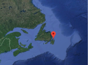
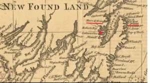
Conception Bay, Newfoundland was one of the first areas of North America to be settled by Europeans. The following Map shows the location of Bareneed (red star) on a 1762 map of southeastern Newfoundland. The locations of St. John’s Newfoundland (Capital of Newfoundland) and Harbour Grace (Harve de Grace) are underlined in red on the Map. Harbour Grace is approximately 20 km north of ‘The Dock’ and historically was the largest town in Conception Bay.
The first Europeans to arrive in this area were migratory fishermen from various European ports who sailed to Conception Bay each spring to fish for cod which was salted and dried on the local beaches then taken back to European markets each Fall. These fishermen were likely visiting Conception Bay prior to Cabot’s voyage of 1497 and by the 1500s they were regular visitors to the sheltered coves (anchorages) on the north west coast of Conception Bay.
The village of Bareneed is situated on the isthmus of the Port de Grave Peninsula which extends into Conception Bay, Newfoundland (see Map). The peninsula separates the inlets of Bay de Grave (to the south) from Bay Roberts (to the north). Most villages on the Port de Grave Peninsular face south towards Bay de Grave since this is the more sheltered side.
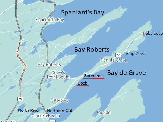
The town of Port de Grave to the East of Bareneed had a more sheltered harbour and was likely the first area of the peninsula to be occupied by visiting fishermen. However, surrounding coves like Ship Cove, Blow me Down, Hibbs Cove (originally Hibbs Hole), Sandy Cove and Bareneed were likely occupied soon after. All of the coves (settlements) east of Bareneed are frequently referred to as Port de Grave by outsiders. Bareneed being separated from the others by a mile of rocky hills retained a separate identity.
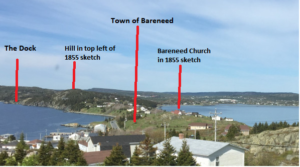
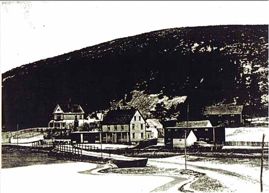
The earliest image of the village of Bareneed is a sketch c 1851 (see below).
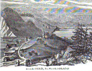
Sketch of Bare Need (Bareneed) c. 1851 (Source: Monthly Record, Society for Propagation of the Gospel in Foreign Parts, March 1855) .
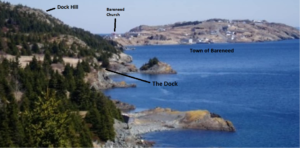
This sketch can be compared with a modern photo showing the same area (see below). The Church (Church of England) is in the center of the sketch and the existing Church (deconsecrated in 2017) was built in 1926 near the location of the church in 1851. Bareneed Cove (location of Wharf and historic center of the town) is in the lower left of sketch and photo. The hill in the top left of the 1855 sketch (see 1980s photo below) is known locally as “Dock Mountain”. The Dock is just behind this hill and is not shown in the 1851 sketch.
In historical records the western part of Bareneed ‘The Dock’ was sometimes considered as a separate village (e.g. in early 20th century Newfoundland census records) but in most historical records it was considered as part of Bareneed. In some cases, both of these villages were considered as Port-de-Grave (a larger town northeast of Bareneed).
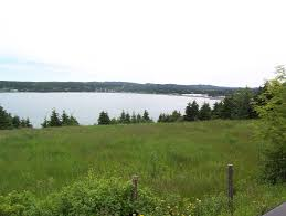
The following photo shows the southern coastline of Bareneed and the Dock’. The view is from west of the Dock (the Otterbury) looking east.
The 1878 Newfoundland Pilot (Admiralty Hydrogr. Dept) describes the south cost of the Port de Grave Peninsular west of Port de Grave as follows:
The coast westward of Port de Grave, is Cliffy as far west as Bareneed…Off the villiage [Bareneed] is a summer anchorage for small vessels in 10 fathoms water… From the village of Bareneed round the head of the Bay to Cupids Cove on the South, there are no dangers or sheltered anchorages.
The Pilot goes on to describe the area at the head of Bay de Grave. At the head of the Bay there is a beach, two streams here empty themselves, one at the north, the other at the south corner of the beach, they are named North Gut and South Gut. The following photo shows a view of the head of Bay de Grave taken from the hills behind South Gut [now the town of South River].
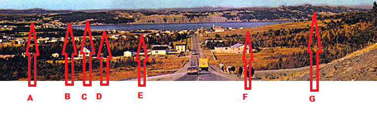
The North Gut referenced in the Pilot is the area where North River flows into Bay de Grave (see “A” and “B” on photo above). Historically, North Gut was frequently used as the boundary between Port de Grave District and Brigus (the next large town to the south). A number of fishermen from Bareneed and Port de Grave relocated to this area in the early 1800s.
The Pilot goes on to describe the area at the head of Bay de Grave. At the head of the Bay there is a beach, two streams here empty themselves, one at the north, the other at the south corner of the beach, they are named North Gut and South Gut. The following photo shows a view of the head of Bay de Grave taken from the hills behind South Gut [now the town of South River].
West of the Dock the south coast of the Port de Grave peninsula has steep cliffs with almost no places to land a boat. This area is called the Otterbury which is the area between “C” and “G” in the photo taken from South River above. The land above the cliffs in the Otterbury had better soil than the areas further east on the Port de Grave Peninsula and this area was settled for farming after a road was constructed between Port de Grave and South River in the early 1830s.